A new, free, app called BCHighways promises to provide easy-to-access roadway information and maps that will make driving easier for B.C. motorists.
BCHighways provides real-time access to provincial highway information, including road closures, planned roadwork, and extreme weather conditions. The app also includes estimated border crossing wait times and traffic camera images, and is designed to assist drivers with route planning before they drive.
���� will tell you driving conditions all over the ����DZ����Գ���,” Transportation Minister Todd Stone told The Journal. “A�Ի� it has the added capacity of being very specific about the real-time driving conditions within 50 kilometers of where you ������.”
The app was developed by AirSenze Solutions, a Victoria-based mobile app development firm. The app uses data from �ٰ����������’s Open511 road event data, and Stone is excited about the results.
“W��’s really cool about it is that we made the 511 road event data available through the BC Development ���泦�Բ���,” says Stone. “W�� have so much [road] information available, and we wanted to encourage software entrepreneurs to access that data at no cost and develop apps.
����’s a really nice complement to the DriveBC site. And there were no taxpayer dollars involved with it, and no effort on the Ministry of �հ����Բ���ǰ��ٲ��پ��Dz�’s part, but it benefits all drivers in the ����DZ����Գ���.”
Drivers should take note, however: the BCHighways app is designed to be used before setting out, or during pauses en route. Using any electronic handheld device while driving is prohibited under ��.��.’s distracted driving law.
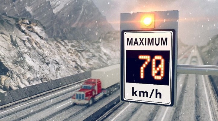
When asked about the variable speed limit signs that were put in place on three stretches of ����ɲ���—i�Գ����ܻ徱�Բ� the ��DZ�ܾ�������—e����������� this year, Stone says that the program has proved very successful. “T��� speed limit has been dropped, to as low as 60 kilometers an hours, 50 or 60 times so far on the Coquihalla, mostly because of heavy rain or construction. But �ɱ�’r�� really keen to see it put to the ultimate test, which is during �ɾ��Գٱ��.”
He says that on November 15, the speed limit on the Coquihalla was dropped to 80 kilometers an hour because of heavy snow. Sensors transmit weather and traffic data in real time to the Regional Transportation Management Centre (RTMC) in Coquitlam. The signs require drivers to slow down to match the speed posted, regardless of the regular speed limits on that stretch of highway.
Weather and traffic data are collected for pavement grip, visibility, temperature, traffic volume, and speed, then transmitted in real time to the RTMC, where a lower speed limit can be authorized by an operator with the appropriate authority to set speed limits.
Instructions are then sent to signs in the field to post the new speed limit.
Stone says that drivers seem to have adapted to the variable speed limit signs. “M�Dz��� motorists are in solid compliance with the speeds ��Dz��ٱ��.”
To download the free BCHighways �����—a���������������� for iPhone, iPad, Apple Watch, Apple TV, and Android mobile ��𱹾������—g�� to .


