A Canadian-made smartphone app designed for assessing mountain terrain has won the hearts of skiers in Revelstoke and across B.C., after its first winter filling a gap for a long-lost predecessor.
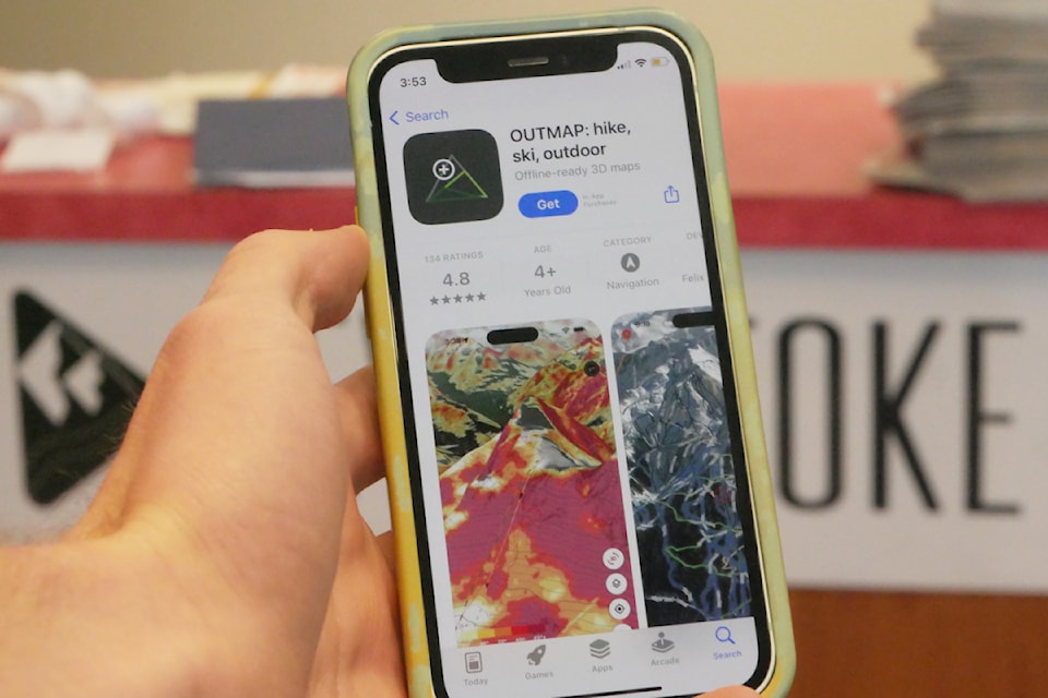
OUTMAP, designed by Montreal-based software engineer and ski tourer F茅lix Gourdeau, launched last October to give winter and summer backcountry users a portable tool for discovering and navigating trails.
Philippe De L'脡toile, a marketing specialist, snowboarder and mountain biker who's known Gourdeau 20 years, has collaborated with his friend on this enterprise since March and watched it take off across Canada and the Pacific Northwest.
Their other co-founding team member, Vancouver-based business entrepreneur Igor Debatur, skis, bikes and supports OUTMAP as head of partnerships.
According to De L'脡toile, B.C. represents more than two-thirds of OUTMAP's user traffic worldwide. Of that, about 50 per cent comes from Vancouver, and 10 per cent from Revelstoke. After the West Coast and Rocky Mountains, the app's next-largest markets are Japan and the European Alps.
It's not the first app of its kind, though.
For almost a decade, hundreds of thousands of backcountry enthusiasts flocked to FATMAP, a resource released from the U.K. back in 2016 that used 3D modelling and crisp visuals to help skiers and snowboarders plan out journeys in complex avalanche terrain. Even when recreationists skied or cycled out of cell service, they could orient themselves using offline maps downloaded from the app.
When FATMAP was in January 2023 by Strava, an American service for tracking and sharing exercise, users anticipated a revamp of their favourite outdoor adventure app.
"Everybody thought that they would integrate it to Strava," De L'脡toile recalled. However, "when FATMAP was bought out, it just shut down."
By last October, the app disappeared from skiers' and trail runners' mobile stores, leaving countless people unsure where to turn for their recreational mapping needs. It was then that Gourdeau sailed an idea by De L'脡toile.
"He just stopped and said, 'well, what if I build my own?'"
Essentially mimicking FATMAP in their design of OUTMAP, Gourdeau, De L'脡toile and Debatur have already scored 4.8 out of five stars on the iOS App Store thanks to more than 130 largely positive reviews. One poster remarks that while Strava may have ruined FATMAP, OUTMAP came to save the day.
"We're rebuilding what people loved but lost," De L'脡toile said, noting his team's own affinity for the slopes and backcountry. "We are always somewhere in the mountains, and that's our defining way."
Since savvy ski tourers use myriad skills and resources while navigating the backcountry, De L'脡toile ultimately wants to deliver a single, compact app that has every feature someone could need. This includes considerations as fine as how easy using OUTMAP is for skiers and snowboarders with frozen fingers.
De L'脡toile is already well aware of how much planning the mountain recreation community dedicates to adventure in the exciting but dangerous backcountry. While he said skiers getting lost or disoriented on their outings isn't a significant issue, safety in avalanche country remains top of mind.
As part of the app's features for helping people tread safely in these environments, "what we do is give slope angles," De L'脡toile said. "We can tell them, 'this is what the terrain looks like.' It's a toolbox."
He also noted that a computer-friendly version of OUTMAP will be ready by next winter for users in the Northern Hemisphere, making the resource all the more accessible.
"The next step for us will be a desktop version," he said. "We're working on that as we speak."
Currently, De L'脡toile's team is performing market research and seeking community input on OUTMAP and what users would like to see added or improved.
"I had targeted the whole western coast of North America to gather feedback," he said. "The feedback from Canada and the Rockies has been higher than elsewhere."
De L'脡toile added that the mountain community, including its "backbone" of experienced guides and emergency responders, has been generous in providing critical feedback on OUTMAP that has proven instrumental for its success and wide application.
"If it's good enough for SAR, it's good enough for average Joe."


